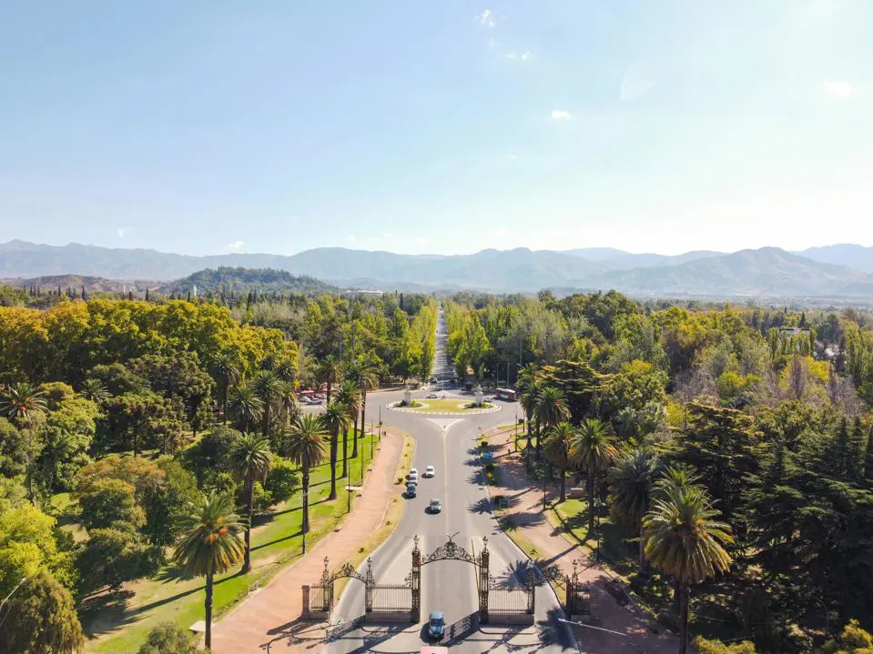
The General San Martín Park is the largest green lung in the province of Mendoza and one of the most important urban parks in Argentina. This space was designed in 1896 by the French landscape architect Carlos Thays and covers 394 hectares of planted forest. At the western end of this park lies the Cerro de la Gloria.
At the top of this historic site awaits not only the most beautiful viewpoint in the region but also the monument to San Martín in Mendoza closest to the capital. The statue pays tribute to the Army of the Andes and the liberating campaign of Argentina, Chile, and Peru.
Below you will find all the information about roads, distances, schedules, transport options, and the history of this place. You can also choose our transfer and guide services to visit the hill and other attractions in Mendoza with tours and excursions.
Guided City and Park Excursions
If you need to optimize your time, touring the historical points accompanied by professional guides is the best option. Joining itineraries with transfers included and visits that combine adventure with information serves this purpose. Cerro de la Gloria and the capital of Mendoza await with all their urban and historical charm if the right excursions are chosen. Let's look at two of the most recommended.
City Tour with San Martín Park and Cerro de la Gloria
This half-day excursion is ideal for obtaining a complete overview of the city and its green spaces. The itinerary of the City Tour with San Martín Park and Cerro de la Gloria begins with the transfer to the Foundational Area (Área Fundacional), where remnants of the city's origin in 1561 and the formation of the old Pedro del Castillo Square persist.
The tour continues in the new city, rebuilt after the 1861 earthquake. Here appear Independencia Square and the Civic Neighborhood. From there it continues west along the stately Emilio Civit Avenue until crossing the Park Gates (Portones del Parque). Inside the General San Martín Park, it is time to learn everything about the irrigation system through acequias (irrigation canals) and Carlos Thays's afforestation work.
Finally, the vehicle ascends via the paved road to the summit of Cerro de la Gloria. There is free time there to observe the details of the Monument to the Army of the Andes and take photographs from the viewpoint.
Historical City Tour
If you are interested in delving into the social, architectural, and seismological processes that shaped the city, the Historical City Tour itinerary is your ideal plan. The tour begins at the San Francisco Ruins, the only architectural vestige of the devastating earthquake that destroyed the capital in the 19th century.
Then it advances towards the General San Martín Park to analyze its function as an ecological belt and purifier of urban air. The excursion ends with the vehicular ascent to the hill, where an iconographic explanation of the friezes and sculptures composing the San Martín monument is given.
Cerro de la Gloria: How to Get There from the City Center
The hill is in the western sector of the city, marking the natural boundary between the urban area and the beginning of the Andes foothills. It is the final point of the main circuit of the General San Martín Park. Unlike other Andean or Patagonian cities, there are very few hills in Mendoza capital integrated into the urban fabric. The city is built on an alluvial plain, making this elevation the first mountain spur accessible from the downtown streets.
Accessibility is one of the strong points of Cerro de la Gloria as a tourist attraction. However, planning the type of experience for the visit depends on the chosen means of transport and the physical condition of the visitors. Access is open every day of the year, and no entrance fee is charged to circulate on the park's public roads.
How to Get to Cerro de la Gloria on Foot or by Private Vehicle
Whether by car or motorcycle, you must follow Avenida del Libertador, which is the continuation of Avenida Emilio Civit starting from the park gates. From there, the ascent is made through a one-way, paved road that winds along the side of the hill for 1.5 kilometers.
At the top, there is a large, free parking lot located right behind the monument. The descent is made via a different paved road that goes down the opposite side.
Those who choose to go up on foot or by bicycle have two alternatives. The first is to use the same paved vehicular road, sharing the route with cars. The second, exclusively for pedestrians, consists of using the dirt trails and stone steps that cut the path vertically up the hillside. This pedestrian trail is signposted, has a low-medium physical difficulty, and allows reaching the summit in approximately 25 to 30 minutes at a normal walking pace.
Buses to Cerro de la Gloria
The urban public transport system (Mendotran) serves to get close to the place. The buses to Cerro de la Gloria do not go up to the top of the monument due to the size of the units and park regulations, but they do drop passengers off at the exact base, from where the pedestrian ascent begins.
Lines 522 and 523 (belonging to Group 500) have routes entering the San Martín Park and have stops in front of the Ecopark entrance and the base of the hill. Another alternative is taking lines 200, 201, or 207 (Group 200), which travel along Boulogne Sur Mer Avenue and drop passengers off at the Park Gates.
From the gates, there is a 3-kilometer walk along Avenida del Libertador to the base of the hill. To use this public service, you must have a loaded SUBE card.
What is the Altitude of Cerro de la Gloria
The exact summit reaches 989 meters (3,244 feet) above sea level. Considering that downtown Mendoza is at an average altitude of 750 meters above sea level, the total ascent from the beginning of the park to the top of the hill represents an elevation gain of approximately 240 meters. This moderate elevation makes it an accessible goal for walkers and cyclists looking for a natural viewpoint without facing the demands of the high mountains.
How Far is Cerro de la Gloria from Mendoza
Taking the city's Kilometer Zero as a starting point (intersection of San Martín Avenue and the Sarmiento pedestrian street, in Plaza Independencia), the exact distance to the base of the hill is 5.5 kilometers (3.4 miles).
The main vehicular route connecting these points is direct. From Plaza Independencia, drive 1.8 kilometers west along Emilio Civit Avenue until reaching the Park Gates. Once inside the park, travel 3 uninterrupted kilometers along Avenida del Libertador, bordering the Rose Garden (Rosedal), the Park Lake, and the Regatas Club, until reaching the roundabout at the base of the hill (in front of the current Ecopark).
Cerro de la Gloria: History of the Park and the Sculptural Work
The area currently occupied by the hill was originally known as "Cerro del Pilar," a rocky and arid promontory without vegetation. The history of the place changed in the early 20th century when provincial authorities decided to forest the foothills and integrate the elevation into the layout of the new General San Martín Park.
The Cerro de la Gloria Monument
The pinnacle of the ascent is the monument inaugurated on February 12, 1914, to commemorate the 97th anniversary of the Battle of Chacabuco. Its creation was promoted by the national government to honor the centennial of the May Revolution and was commissioned to the Uruguayan sculptor Juan Manuel Ferrari, who cast the bronze pieces at the National War Arsenal in Buenos Aires.
The monument is 16 meters high and is supported on a massive base built with stones extracted from the mountain town of Uspallata. The work stands out for its historical rigor, as Ferrari studied the uniforms, weapons, and customs of the San Martín era to model the figures.
Unlike traditional representations, the equestrian statue of General José de San Martín does not show him with his arm raised pointing the way. In this work, San Martín is on his horse with his arms crossed over his chest and a serene gaze, looking at the horizon towards the mountain range. Around him are the Mounted Grenadiers (Granaderos a Caballo).
Panoramic View and Services
The final attraction of this site is its scenic value, as the view is considered the best panoramic postcard of Greater Mendoza. The main viewpoint faces east and southeast. From there, you can observe the immense forest mass of the General San Martín Park, acting as a green border before the city's urban fabric.
Towards the west, behind the monument, the view changes radically to show the first arid foothills of the precordillera. At these heights, Cerro Arco dominates, and the mountains announcing the beginning of the Andes Mountain Range appear.
The summit has complete service infrastructure:
Access ramps for people with reduced mobility connecting the parking lot with the base of the monument.
Permanent police security post.
Free public restrooms.
Stalls selling local handicrafts.
A cafe where it is possible to buy drinks, fast food, and regional products.
Published by Has Chacon on 08/06/2026